Chris Cimino's forecast for Friday, June 7.
Morning Forecast for Friday, June 7
Copy
Close
Link to this video
http://www.nbcnewyork.com/video/#!/weather/stories/Morning-Forecast-for-Friday,-June-7/210540311
Copy
Close
Embed this video
Replay
advertisement
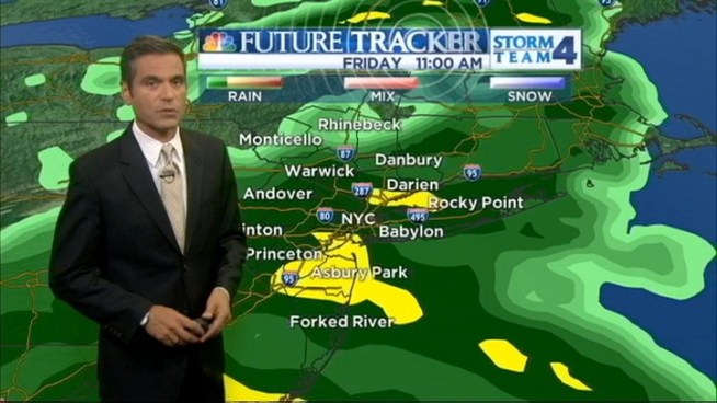
Steady rain began saturating much of the tri-state area Friday ahead of several bands of heavy, persistent downpours that are expected to cause widespread flash flooding as the remnants of Andrea, the first named storm of the Atlantic hurricane season, churn up the East Coast. Forecasters say the torrential rain will begin to batter the region by early afternoon, lasting through the evening commute and causing problems into the overnight hours.
A flash flood watch is in effect for all of New York City, Long Island and most of upstate New York, as well as for New Jersey and most of Connecticut. Water had already begun pooling on streets and sidewalks in the city and poor drainage areas in New Jersey by Friday morning.
Flight delays at the area's three major airports had also been reported.
Track all severe weather alerts and follow the storm using our interactive radar here.
Though Andrea is expected to be downgraded to an extra-tropical storm at some point Friday, forecasters say the risk for flooding downpours in the tri-state area remains. Meteorologists say another 3 inches of rain are expected to fall Friday afternoon, adding to the inch or so that fell in the morning.
That amount of rain over a relatively short period heightens the risk for flooding, particularly in low-lying areas and on streets and highways in cities like Hoboken, N.J., where water doesn't drain efficiently even when it only rains a little bit.
Hoboken suggested residents move their cars to higher ground and offered discounted parking at two garages. The city also activated its emergency response system ahead of the storm.
Resident Brian Smalleys, who spent hundreds of thousands of dollars repairing his home after Sandy, said he has trouble sleeping when it rains heavily now.
“I just get nervous, I don’t want it to happen again,” he said.
Nearby Jersey City is setting up barricades along flood-prone streets.
There's a high rip current risk along the Jersey shore with surf heights of 4 to 6 feet and the high rainfall totals could also send rivers flowing over their banks.
Any lingering rain is expected to move out Saturday morning, giving way to mostly sunny skies and temperatures in the mid-to-high 70s by the afternoon.
Get the latest from NBC 4 New York anywhere, anytime: iPhone/iPad App | SMS Alerts | Twitter | Facebook | Google+ | Instagram | RSS
Get the latest headlines sent to your inbox!
